Partner Article
How Satellite Technology Can Enhance the Agritech Sector
There a lot of challenges humans will face in the near future. These include a rapidly rising population, food shortages, and environmental issues, to name a few.
Luckily for us, the agritech sector is making strides to help combat some of these issues, by making agriculture more efficient and cost-effective.
We can also use satellite technology and space data to enhance some of the current progress being made in this sector. While space and agriculture may not seem a likely fit, the data pulled from satellite monitoring can massively improve our current processes.
Here’s our guide on how satellite technology can enhance the agritech sector:
How Can Space Help Agriculture? The first question to ask is how the two (space and agriculture) can be linked together.
By using satellites to monitor fields remotely, we can pull data from this perspective to help us on the ground-level. For example, a big problem many farmers face is the unpredictability in weather patterns. While we can accurately predict certain conditions to an extent, we can’t do so with 100% accuracy.
Satellites will be able to more accurately predict the upcoming weather conditions and relay that information to us in real-time. Not only will they predict the weather, but they can also use that data to figure out when to grow certain crops.
Ground-level issues such as irrigation and fertilisation can also be monitored, and the data fed back to farmers can help them decide their next course of action. Knowing the optimum strategy in advance can help maximise efficiency and reduce overall costs, as it presents a lesser likelihood for mistakes.
With agricultural activity being monitored from afar, data can be pulled on many major parts of the process, thus aiding in their optimisation and a better workflow overall. This, in turn, will result in benefits across the board for farmers, agricultural markets, and the consumers.
You can find a more detailed understanding of the current farming climate here.
**What the Future May Hold **There are some key areas already mapped out where space data can massively affect agriculture and the processes involved.
Farm Water Management Water is a huge issue for farmers.
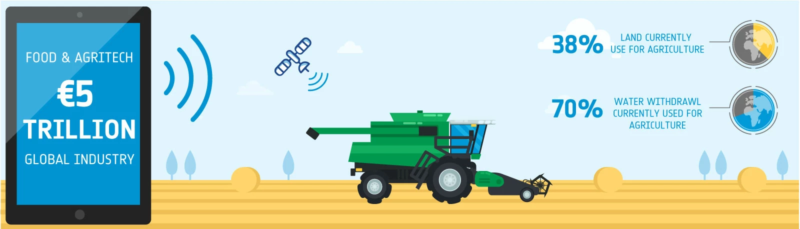
Water conservation is extremely important, but 70% of the world’s water withdrawal currently stems from agricultural use.
Instead of evenly watering crops across the entire field, satellites will help determine how much water is needed for each individual crop. By distributing the water more efficiently, there is less chance of wastage as well as over-irrigation.
A potential of 18%-30% of farm water can be conserved by utilising satellite technology.
Crop Fertilisation In a similar fashion to the previous entry, satellites can also help determine which crops need more fertilisation than others.
Crops are not unanimously healthy across the field. Realistically, some crops require more fertiliser than others to achieve their optimum growth. Over-fertilisation can have a negative environmental impact – by pinpointing exactly which crops need fertilising, the possibility of using too much is heavily reduced.
Autonomous Vehicles One incredible leap forward may involve a complete absence of farmers in the field.
We can utilise space data to figure out the most efficient route through the fields for crop yielding, and from there take advantage of driverless technology so that the tractors and harvesters manoeuvre these routes autonomously.
The routes can be inputted into the vehicle’s GPS and it’ll complete the route while being monitored by the farmers, reducing the chances for human error and maximising efficiency.
Farm Animal Tracking We’ve talked a lot about field and crop management, but satellites can also be used to help monitor livestock.
Each animal’s location will be tracked remotely, while a device is attached to each animal, measuring some vital signs such as temperature, behaviour and sleep cycles.
Satellite communication will alert the farmers of any unusual activity, making suggestions on what steps to take to rectify any potential issues. Tracking the livestock will also reduce theft along with the spread of illness to other livestock.
All the information will be known in real-time, meaning action can be taken in the quickest amount of time possible to reduce a “chain reaction” of problems.
What’s Currently Being Done? At the current time, there are plenty of projects underway implementing space data into the agriculture sector.
SolumScire This project aims at understanding soil conditions when it comes to utilising space data for crop production. The service’s overall goal is to adjust and improve field related precision farming activities by supplying this soil condition data.
Ideally, this will add value to the farmers using the service due to an increase in yields and yield stability, while at the same time reducing emissions from general crop management.
Grapelook Grapelook has its targets set on grape farmers, aiming to promote sustainable optimal resource utilisation by managing scarce irrigation water resources.
This method should help reduce costs AND protect the environment, while also increasing the efficiency of water use in places such as Western Cape in South Africa. Satellite data will help monitor the overall consumption and offer up solutions on how best to use whatever water and fertiliser remains.
Greenspin Agri Planet Using satellite data analysis alongside collected crowd information, Greenspin’s service offers real-time insights on various agricultural conditions, utilising machine learning and intelligent algorithms to pull big data from satellites observing the Earth.
This all aims towards effectively forecasting crop yields as well as the quality of those yields, aiding decision makers in the agricultural businesses towards their next steps.
Agriloc Agriloc’s main focus is precision farming, and how best to achieve this.
The service utilises satellite navigation and telecommunication to provide this service, hoping to enhance the farming process on a larger scale.
Their overall aim is to boost productivity, machine availability and user-friendliness while simultaneously reducing production costs and any negative impacts to the environment.
Fertisat As explained in the section before, there is a demand for optimised fertilisation in crops, one that is both effective and affordable.
This is Fertisat’s main goal – to precisely determine which crops need fertilisation and alleviate any over-fertilisation, which could negatively affect the environment.
Fertisat uses a mapping system taking specific crop requirements into consideration, alongside moisture and weather conditions which could potentially absorb the fertiliser. Intelligent algorithms are employed, making use of optical imagery from the satellites orbiting Earth, in conjunction with weather forecasting tools.
This was posted in Bdaily's Members' News section by Charles .
Our Partners


 Creating the conditions for North East talent to thrive
 Why local government is key to devolution success
 Your reputation is worth more than that invoice
 There is no perfect time when selling a business
 What next when social media career help goes?
 The psychological contract that nobody signs
 Time for strategy built on the foundational economy
 Why being ‘work-ready’ matters more than ever
 The North's future doesn't end at Manchester
 Exit or legacy? Why every owner needs a plan
 Who speaks up for SMEs when giants get bigger?