Newcastle International becomes first English regional airport with Apple Maps integration
Newcastle International is giving passengers a new tool for navigating through the airport in a deal with Apple Maps.
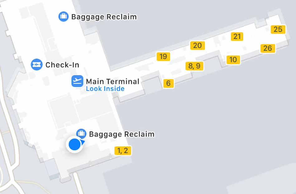
The airport has become the first of England’s regional hubs to bring detailed maps of its terminals to the software, enabling passengers to better plan their journey through the airport using their iPhone or iPads.
It means Apple Maps now features information on the restaurants, cafes and shops available in Newcastle International’s terminals, as well as points of interest like toilets, baggage claim and security checkpoints.
Passengers can also use Apple Maps to see exactly where they are between all three of the airport’s floors, ensuring they know exactly where to go next.
Information regarding new stores and locations will be added as Apple Maps is updated.
Newcastle Airport’s marketing and communications manager, Kate Hall, said: “It is absolutely brilliant that this service is now available at our airport ahead of other regional airports across the country.
“With Apple Maps at Newcastle, our passengers will be able to move more quickly and efficiently though the airport which will add to the overall customer experience.”
She continued: “It will also provide a useful tool for passengers who are more nervous about their journey – as they will be able to have a look around the building before their day of travel.
“We hope that our passengers will use this exciting new piece of technology to its full potential.”
Only three other UK airports have integrated with Apple Maps: Gatwick, Heathrow and Edinburgh.
Last year, Newcastle International strengthened its digital offering with the launch of its own app.
Want your business, product or service to be seen regionally and nationally? Bdaily helps you get your story in front of the right audience, every day. Find out how Bdaily can help →
Join more than 55,000 subscribers by signing up to our daily bulletin each morning here.
Enjoy the read? Get Bdaily delivered.
Sign up to receive our daily bulletin, sent to your inbox, for free.
Our Partners


 What next when social media career help goes?
 The psychological contract that nobody signs
 Time for strategy built on the foundational economy
 Why being ‘work-ready’ matters more than ever
 The North's future doesn't end at Manchester
 Exit or legacy? Why every owner needs a plan
 Who speaks up for SMEs when giants get bigger?
 The true value of HR in an AI-driven working world
 What new business rates guidance means for pubs
 Business success starts with people investment
 It's time to confront the digital poverty crisis
 Why a business exit is no longer all or nothing